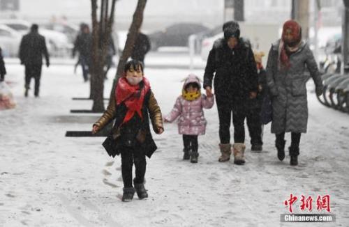
Chinanews. com client January 3 rd Comprehensive news, the Central Meteorological Observatory issued a yellow warning of blizzard on the morning of the 3 rd. It is predicted that there will be snowstorms in Shaanxi, Hubei, Henan, Anhui and other local areas in the next 24 hours. Today and tomorrow, a round of rain and snow will enter the peak stage, and the precipitation will spread to 23 provinces, and the local precipitation may exceed the historical extreme value, so it is necessary to guard against the adverse effects on traffic.
There are snowstorms in five provinces including Shanxi, Hubei and Henan, and freezing rain in Hubei and Guizhou.
Affected by the eastward movement of the south branch trough and the southward cold air, a large-scale rain and snow weather process will occur in most parts of central and eastern China from 3 to 4, with moderate to heavy snow in the eastern part of northwest China, southwestern part of North China, most of Huanghuai, Jianghan, Jianghuai and other places. Among them, there are heavy snow in parts of central and southern Shaanxi, western and northern Hubei, southern Henan, northern Jiangsu and Anhui, local heavy snow, and freezing in parts of southwestern Hubei, northwestern Hunan and northeastern Guizhou.
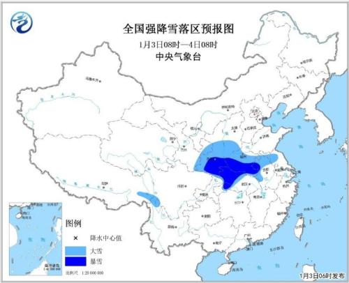
From 8: 00 on the 3rd to 8: 00 on the 4th, there were heavy snowstorms in Shaanxi, Shanxi, Hubei, Henan and Anhui. There are moderate to heavy snow or sleet in the eastern part of northwest China, south-central Shanxi, central and western Huanghuai, northern Jianghuai, Jianghan and southeastern Qinghai-Tibet Plateau, among which there are heavy snow (10 ~ 18 mm) in parts of south-central Shaanxi, western and northern Hubei, southern Henan and northwestern Anhui. There are moderate to heavy rains and local heavy rains in parts of the eastern and southern parts of southwest China, northern Jiangnan and northwestern Guangxi. There will be 6-8 winds and 9-10 gusts in the northern, central and southern parts of the South China Sea and bashi channel, and the winds in some sea areas can reach 9 and 10-11 gusts.
From 8: 00 on the 4th to 8: 00 on the 5th, there were heavy snowstorms in Henan, Hubei, Jiangsu, Anhui and other places. There are moderate to heavy snow or sleet in southern North China, most of Huanghuai, Jianghuai, Jianghan, northwestern Jiangnan and northeastern China. Among them, there are blizzards in parts of southeastern Henan and central and northern Jiangsu and Anhui, and there are heavy blizzards in the local area. There are freezing rains in parts of northwestern Hunan and eastern Guizhou. There are small to moderate rains in the eastern part of southwest China, southern Yunnan, central and eastern Jiangnan, and southern China, and there is heavy rain in the local area. There will be 6-8 winds and 9-10 gusts in the southwestern part of the South China Sea.
From 8: 00 on the 5th to 8: 00 on the 6th, the snowfall in the central and eastern regions gradually weakened. There are small to medium snow or sleet in western Inner Mongolia, eastern Northwest China, western North China, western Huanghuai, Jianghan, western Jianghuai and northwestern Jiangnan, with heavy snow in the local area, and freezing rain in parts of southwestern Hubei, western Hunan and eastern Guizhou. There is light rain in the eastern part of Southwest China, southern Yunnan, central and eastern Jiangnan, southern China and Taiwan Province, and there is moderate rain or heavy rain in the local area. In the northern part of the East China Sea, there will be northerly winds with 6-8 grades and gusts of 9 grades.
Rain and snow affected snowstorms or extreme values in 23 provinces, such as Henan and Hubei.
According to the news of China Weather Network, it is predicted that the first round of rain and snow will enter the peak stage this year and tomorrow, and the precipitation will spread to 23 provinces in northwest, north China, southwest and south of the Yangtze River, among which there will be heavy snow in parts of five provinces including Shaanxi, Henan and Hubei. Snowfall is beneficial to the growth of overwintering crops, and can reduce dryness and eliminate haze, but the local precipitation may exceed the historical extreme value, so it is necessary to guard against the adverse effects on traffic.
The monitoring shows that the rain and snow process has a wide range, which will spread to the eastern northwest, southern North China, the eastern southwest and Jiangnan, affecting 23 provinces (autonomous regions and municipalities), and the precipitation range will exceed 4 million square kilometers. Among them, heavy snowfall lasts for a long time in southwestern Shaanxi, Henan, northern Anhui and northern Jiangsu.
Today and tomorrow, rain and snow will enter the peak stage, with heavy snow in parts of Shaanxi, Henan, Hubei, Jiangsu, Anhui and other places. Among them, today’s rain and snow are the most prosperous, and the boundary between rain and snow will also move eastward and southward to the south of Shaanxi, the northwest of Hubei and the Jiangsu-Anhui-Huaihe River. The day after tomorrow, a large range of rain and snow developed eastward, and the dividing line between rain and snow further pressed southward and eastward.
In addition, snow and ice will also have an adverse impact on traffic. On the highway side, this snowfall may lead to more than 10 cm of snow in the areas of southern Shaanxi, southwestern Shanxi, western Hubei, south-central Henan and northern Jiangsu and Anhui. The sections of Beijing-Hong Kong-Macao Expressway, Daguang Expressway, Erguang Expressway, Lianhuo Expressway, Shanghai-Shaanxi Expressway and Ningluo Expressway passing through the above areas may be temporarily closed on 3-4 days. In terms of air transport, flights may be delayed or even cancelled at airports in Xi ‘an, Zhengzhou and Xuzhou. Remind the public with travel plans to arrange their trips reasonably, and pay attention to traffic safety and drive carefully when going out.
The cooling area crosses the Yangtze River, Wuhan, Changsha and other places with the highest temperature near freezing point.
Yesterday, under the influence of rainy weather and cold air, there was a large-scale cooling from northwest, north and northeast to Huanghuai, western Jianghuai and Jianghan. The monitoring shows that the temperature in Gansu, Ningxia, Shaanxi, western Inner Mongolia, Shanxi to Henan, northern Shandong and northern Anhui dropped by 4-8℃ compared with the previous day, and the local temperature was about 10℃.
Today and tomorrow, with the full spread of rain and snow and the influence of cold air, the cooling area will gradually cross the Yangtze River and extend to the southwest and most of the south of the Yangtze River. It is estimated that the maximum temperature zero line will be pushed south to Huanghuai area on the 4th to 5th. For example, the maximum temperatures in Xi ‘an and Zhengzhou will fall below freezing point for the first time this winter, and Wuhan, Hefei, Nanjing and Changsha in the middle and lower reaches of the Yangtze River will also drop to 0℃.
The lowest temperature zero line will extend to the Yangtze River again, and it will be wet and cold in the morning and evening. However, in the eastern part of northwest China, the western and northern parts of North China and the western part of Huanghuai, it will fall below -10℃, and it is also a frozen person. For example, in Zhengzhou, the highest temperature is still 9.2℃ on the 1st, and it will drop to -4℃ on the 5th, which is more than 10℃ lower than normal. On the morning of the 5th, the lowest temperature may be as low as -11℃, which will not only be the lowest temperature since this winter, but also break the record of the lowest temperature since 2000.

Beijing’s cold wind blew and the highest temperature dropped to freezing point on the 4th.
It is expected that the north wind will rise again in Beijing today, with a gust of 5-6. The public should pay attention to wind protection and warmth when going out. It will be cloudy in the next three days, and the temperature will drop to the lowest point this week tomorrow. The highest temperature is only 0℃, and the lowest temperature is -8℃ from night to the next morning. The chill is strong, so it is necessary to pay attention to cold protection.
The temperature in Beijing will fluctuate in the next three days. Today, the north wind is relatively strong during the day. The Beijing Meteorological Observatory predicts that it will turn sunny to cloudy during the day, with north winds of three or four, gusts of five or six, and the highest temperature of 2 C; It is cloudy at night, with a northerly wind of four or three, and the lowest temperature is -5℃.
It will turn cloudy tomorrow and the temperature will drop to the lowest point this week. It is estimated that the maximum temperature during the day is only 0℃, and the minimum temperature from night to the next morning is -8℃, with a strong chill. It will be cloudy and sunny the day after tomorrow, and the maximum temperature will rise to 3℃.
关于作者